Model Exam Answers
- Explain how a sand spit is formed. [Higher 6 marks]
Answer: Spits are long ridges of sand and shingle with one end attached to the land and the other ending in the open sea. For example – Spurn Head on the Yorkshire coast. A spit will form when sand and shingle are carried along a coast by longshore drift. This is when waves approach a beach at an oblique angle, break and transport material up the beach but the backwash returns to sea at a right angle to the coast. Material is therefore gradually transported along the beach in the direction of the dominant wind. If there is a bay or a bend in the coastline, deposition of sand and shingle will continue to be deposited away from the coast in the open sea. This will build up in time to form a long ridge; sometimes winds and currents may curve the spit.
2. Using one or more examples, describe the human responses to coastal erosion. [6 marks]
Answer: There are two main approaches to coastal erosion, hard and soft engineering. Hard engineering involves building solid substantial sea defences, which cost a lot of money. These can include the building of groynes at right angles to the coast to stop the movement of sand. E.g. Bournemouth. Another method is the building of expensive sea walls to protect the land. This is being tried at Scarborough where the local council is spending £30 million. Other defences include gabions which are steel mesh cages containing boulders and armour blocks when large boulders are piled on the beach where erosion is likely. None of these hard engineering projects are sustainable in the long term. There has now been a move to soft engineering projects.
The easiest soft engineering project is to leave the sea to do what is wants, but others include beach nourishment where more mud or sand is placed on the beach. In the west coast of France they have tried shoreline vegetation such as pine trees to hold the beach sediment together and dune stabilisation, as dunes are an excellent defence against the sea.
1. Explain how feature Z was formed. [Higher 6 marks]
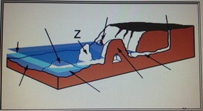
Answer: Feature Z is a stack, which at one time will have been connected to the headland. A crack or weakness in the headland will be eroded by the sea to form a cave. Further erosion enlarges the cave and it breaks through the headland to form an arch, e.g. Durdle Door, Dorset. The roof of the arch is often unstable and will be attacked by the sea and by weathering. Eventually the roof will collapse leaving a stack such as Old Harry. Sometimes you get a series of stacks such as The Needles off the Isle of Wight. Areas with limestone or chalk rocks are prone to this type of erosion.
1. Explain how and why cliff collapse occurs in some coastal locations. [Foundation 4 marks]
Answer: In some areas of the coastline the bottom of the cliff can be attacked by destructive waves. This erosion by waves undercuts the rock face to form a wave cut notch. The overhanging rock will collapse. If this happens many times the cliff retreats inland. This is more likely to happen in areas where the fetch of the waves is long and the waves are destructive, such as in Cornwall and Devon. There will also be more erosion if the rock is soft such as clay on the Yorkshire coastline.
1. The diagram below is a cross section along a coast. Explain how feature Y was formed. [Higher 6 marks]
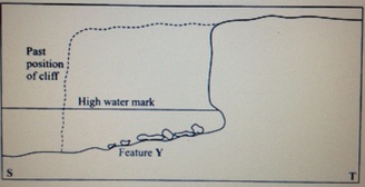
Answer: Feature Y is a wave cut platform. When the sea attacks the cliff it will attack the bottom of the cliff first. Over time a wave cut notch will form. This notch will become bigger and bigger and eventually the rock above the notch will become unstable and collapse. This process then continues over and over again and the cliff slowly retreats. As you can see from the diagram the original position is marked. The flat area in front of the cliff is called a wave cut platform and is usually only visible at low tide. This is the area that was originally the bottom of the cliff.
Example exam questions (AQA A level)
Explain the ways in which a coastal habitat can be managed sustainably. (6 /8 marks)
For a coastal environment that you have studied, describe the environment and explain why it provides a suitable habitat for the species living there. (6 marks)
Study Figure 3 which shows evidence of mass movement south of Mappleton on the Holderness coast. Define the term ‘mass movement’ (2 marks).
Describe evidence in Figure 3 which shows that mass movement has occurred (4 marks).
Describe physical causes of coastal erosion (5 marks).
Explain how beach nourishment can reduce coastal erosion (4 marks).
Hard engineering has been used to protect some coasts. With reference to a case study, explain how hard engineering can protect the coast and comment on its effectiveness (15 marks).
Study Figure 5 which shows the size of beach material along Criccieth beach, Cardigan Bay. Describe the pattern shown by the data in Figure 5 (3 marks).
Suggest reasons for the pattern shown by the data in Figure 5 (4 marks).
Describe how the dunes change inland (3 marks).
Explain the conditions needed for the development of coastal dunes (5 marks).
Using a case study, assess the causes and consequences of coastal flooding (15 marks).
Describe the characteristics of constructive waves (2 marks).
Outline the effects of constructive waves (3 marks).
Explain the role of sub-aerial weathering in coastal environments (4 marks).
Explain the formation of headlands and bays (6 marks).
Discuss issues relating to a coastal area where soft engineering management strategies have been adopted (15 marks).
