Coastal Erosion Features
There are 3 main groups of coastal features which result from coastal erosion:
1. Headlands and Bays
2. Caves, Arches, Stacks and Sumps
3. Cliffs and Wave-cut platforms
1. Headlands and Bays
2. Caves, Arches, Stacks and Sumps
3. Cliffs and Wave-cut platforms
1. Headlands and Bays
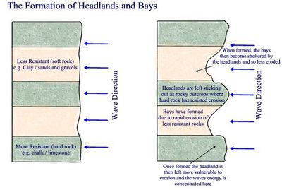
Headlands are resistant outcrops of rock sticking out into the sea, whilst bays are indents in the coastline between two headlands.
So how do headlands form? - Headlands form along discordant coastlines in which bands of soft and hard rock outcrop at right angles to the coastline.
- Due to the presence of soft and hard rock, differential erosion occurs, with the soft, less resistant rock (e.g. shale), eroding quicker than the hard, resistant rock (e.g. chalk)
- Where the erosion of the soft rock is rapid, bays are formed
- Where there is more resistant rock, erosion is slower and the hard rock is left sticking out into the sea as a headland.
- The exposed headland now becomes vulnerable to the force of destructive waves but shelters the adjacent bays from further erosion.
Named Examples of Headlands and Bays
The Dorset coast has excellent examples of Headlands and Bays
e.g. Swanage Bay and the Foreland (a headland)
2. Caves, Arches, Stacks & Stumps
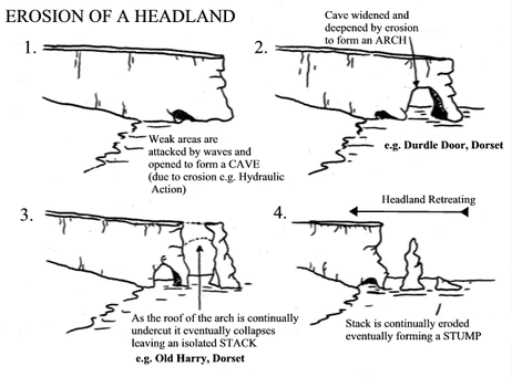
Once a headland has formed it is then exposed to the full force of destructive waves and it gradually begins to erode. you need to be able to describe the erosion of a headland and the features that form.
So how does a headland erode and caves, arches, stacks and stumps form?
- Firstly, the sea attacks the foot of the cliff and begins to erode areas of weakness such as joints and cracks, through processes of erosion such as hydraulic action, wave pounding, abrasion and solution;
- Gradually these cracks get larger, developing into small caves;
- Further erosion widens the cave and where the fault lines runs through the headland, two caves will eventually erode into the back of each other forming an arch, passing right through the headland.
- A combination of wave attack at the base of the arch, and weathering of the roof of the arch (by frost, wind and rain), weakens the structure until eventually the roof of the arch collapses inwards leaving a stack, a stack is a column of rock which stands separate from the rest of the headland.
- The stack will continue to erode, eventually collapsing to form a stump which will be covered by water at high tide.
Named Examples:
The Foreland (Dorset Coastline) is a great example of a headland which shows these features - there is a distinctive stack called Old Harry and a stump known as Old Harry's Wife.
A good example of a distinctive arch, also found on the Dorset Coast is Durdle Door.
3. Cliffs and Wave-cut Platforms
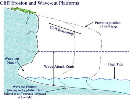
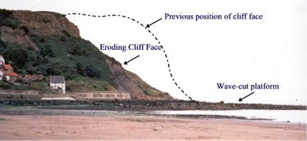
Cliffs are steep rock faces along the coastline, they tend form along concordant coastlines with resistant rocks parallel to the coast.
So how do cliffs and wave-cut platforms form?
- The erosion of a cliff is greatest at its base where large waves break - here hydraulic action, scouring and wave pounding actively undercut the foot of the cliff forming an indent called a wave-cut notch whilst the cliff face is also affected by abrasion as rock fragments are hurled against the cliff by the breaking waves.
- This undercutting continues and eventually the overhanging cliff collapses downwards - this process continues and the cliff gradually retreats and becomes steeper.
- As the cliff retreats, a gently-sloping rocky platform is left at the base, this is known as a wave-cut platform which is exposed at low tide.
Named Examples:
Good examples of cliffs and wave-cut platforms can be found at Hunstanton (North Norfolk) and Flamborough Head (Yorkshire)
Coastal Deposition Features
Material that is transported by the waves along a coastline is eventually deposited forming distinctive deposition features. There are four main deposition features that you need to learn the formation of. These are:
1. Beaches
2. Spits
3. Bars
4. Tombolos
1. Beaches
2. Spits
3. Bars
4. Tombolos
1. Beaches
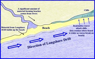
Beaches Beaches are the main feature of deposition found at the coast, these consist of all the material (sand, shingle etc.) that has built up between the high and low tide mark. There are number of different sources of beach material - the main source being rivers, where fine muds and gravels are deposited at the river mouth. Other sources of beach material include longshore drift (bringing material from elsewhere along the coast); constructive waves (bringing material up the beach from the sea) and from cliff erosion.
As constructive waves build up beaches, they often form ridges in the beach known as berms. The berm highest up the beach represents the extent to which the water has reached during high tide.
As constructive waves build up beaches, they often form ridges in the beach known as berms. The berm highest up the beach represents the extent to which the water has reached during high tide.
2. Spits
Spits are long narrow ridges of sand and shingle which project from the coastline into the sea.
The formation of a spit begins due to a change in the direction of a coastline - the main source of material building up a spit is from longshore drift which brings material from further down the coast.
Where there is a break in the coastline and a slight drop in energy, longshore drift will deposit material at a faster rate than it can be removed and gradually a ridge is built up, projecting outwards into the sea - this continues to grow by the process of longshore drift and the deposition of material.
A change in prevailing wind direction often causes the end of spits to become hooked (also known as a recurved lateral).
On the spit itself, sand dunes often form and vegetation colonises (for example Blakeney Point - North Norfolk)
Water is trapped behind the spit, creating a low energy zone, as the water begins to stagnate, mud and marshland begins to develop behind the spit;
Spits may continue to grow until deposition can no longer occur, for example due to increased depth, or the spit begins to cross the mouth of a river and the water removes the material faster than it can deposited - preventing further build up.
Examples of Spits
- Spurn Head - Holderness Coast
- Orford Ness - Suffolk
3. Bars
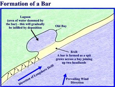
These form in the same way as a spit initially but bars are created where a spit grows across a bay, joining two headlands. Behind the bar, a lagoon is created, where water has been trapped and the lagoon may gradually be infilled as a salt marsh develops due to it being a low energy zone, which encourages deposition.
Example of a Bar: Slapton Sands - Devon.
Example of a Bar: Slapton Sands - Devon.
4. Tombolos
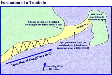
Tombolos are formed where a spit continues to grow outwards joining land to an offshore island.
Example of a Tombolo: - Chesil Beach - which joins the South Dorset coast to the Isle of Portland.
Example of a Tombolo: - Chesil Beach - which joins the South Dorset coast to the Isle of Portland.
